Railway Department Park: From Waterways to Railways on Old Maps | 2024 Open House Taipei
Who built the 1st railway in Taiwan?
Why did they build it?
Are we still able to see the infrastructure after 100+ years now?
If you are also curious about the answers, listen to the stories which were taught by The Railway Department Park of National Taiwan Museum!

Railway Department Park of National Taiwan Museum at 2024/01/20
---------------
National Taiwan Museum and its branches carry a rich and diverse historical legacy, including Paleontology Museum (originally a large bank during the Japanese era), the Nanmen Park (formerly a camphor and opium processing factory), and the Railway Department Park, which is the protagonist today. Each branch preserves essential fragments of Taiwan’s multi-cultural history.
The previous piece of article was focused on the camphor and opium industries in Taiwan’s history and the park. This time, the focus shifts to the Railway Department Park, exploring the historical development of Taiwan’s railway system. To better understand this history, let’s first revisit how the old maps of Taipei tell the stories.

1887 “A Depiction of Taipei City in Qing Dynasty”
In the map of “A Depiction of Taipei City in Qing Dynasty (1887),” the area now known as Taipei City lacked clear urban structures. So we cannot make sure what facilities were there.

Taipei Prefecture (1888)
However, just one year later, in the map of “Taipei Prefecture (1888),” the Taipei Machinery Bureau (a manufacturing facility established as part of modernization and westernization reforms) appeared at the bottom of my screenshot.
Located near Beimen (literally “North Gate”), which was one of the five main gates of Taipei’s ancient city walls, this facility was strategically placed in the city center to leverage the area’s proximity to the nearby Tamsui River for transportation purposes.
The Machinery Bureau initially manufactured bullets and repaired firearms but was limited by the technology of the time. Its production capacity was sufficient only for military training needs. By 1892, it expanded its functions to include minting coins, repairing railways, and transporting timber. This transition marked its evolution from a military facility to a multi-functional slightly modernized industrial factory.

The Outline of Taipei, Dadaocheng, and Bangka (1895). The highlighted areas are the bureau and the river.
During the Japanese colonial period (1895–1945), maps such as the map of “The Outline of Taipei, Dadaocheng, and Bangka (1895)” labeled the Machinery Bureau as the “Former Machinery Bureau,” reflecting the changes as the ruler shifted from Hans to Japanese.

Recently Surveyed Map of Taipei (1903) The highlighted area on the left is the title of the map, which was presented creatively; the parts on the right side are the waterways and railways.
By 1903, the area was marked as the “Railway Department” on the “Recently Surveyed Map of Taipei (1903),” signifying its transformation into a railway and train maintenance hub.
---------------
The reason why Japanese removed the buildings was not out of disdain but due to practical concerns. The railways built during the Qing dynasty were technically inadequate: the trains were slow, routes were poorly designed, and some slopes required passengers to push the train uphill.

Railways in the center of Taipei
To establish a functional and modern railway system, the Japanese government redesigned the routes and relaid the tracks with more modernized technology.

Taipei Urban Reformation Map (1905). The highlighted areas are the river, the railways, and the Railway Department.

Taipei Urban Reformation Map (1905). Zoom out to have a clear look. The area was called as “河溝頭,” which literally means the root of a river. Why it’s named like that will be explained in the latter part of this article.
By 1905, the “Taipei Urban Reformation Map” showed multiple railway tracks extending into the Railway Department, resembling the design of modern train maintenance depots. With the gradual completion of Taiwan’s trail lines, the Railway Department’s workload increased significantly.
This map also depicted the disappearance of Taipei’s city walls, replaced by a newly constructed roundabout — a symbol of urban modernization at that moment. Roundabouts represent modernization because of its traffic efficiency, safety, urban design benefits, etc.
To meet growing demands, part of the original building’s southern section was dismantled in 1918, and the main building we see today was constructed in 1919 to be an administrative hall. The building’s design reflects the architectural diversity of the site, which combined the Japanese and the European style, and the layered history of its development.

Railway Department Park of National Taiwan Museum at 2024/01/20. The logo on top of the gate represent Taiwan Railway.
The new administrative hall was designed by Matsunosuke Moriyama, an staff working at a government department and a student of the renowned architect Kingo Tatsuno. The red-white style is also called Tatsuno style. The stories of Prof. Tatsuno was also introduced in the previous episode.
The construction was carried out by Takaishi Company and Sumiyoshi Company, two prominent construction firms of the era.
Takaishi Company, based near the Railway Department, also contributed to the construction of notable landmarks such as the National Taiwan Museum, and various infrastructure projects like roads and water sewage systems. To know more about the stories of its founder, Tadao Takaishi, please read this picture book: https://www.books.com.tw/products/0010881188
Sumiyoshi Company, founded by Hidematsu Sumiyoshi, was headquartered in Tainan (southern Taiwan) with a branch in Taipei. The firm specialized in railway construction and public works, including the Alishan Railway and the Tainan Police Department. Sumiyoshi also established a volunteering firefighter system in Tainan, earning him the title “Father of Firefighting in Tainan.”
Under the collaboration of these two firms, the main building of the Railway Department was completed at 1920, standing as a testament to the era’s architectural ingenuity and Taiwan’s early modernization efforts.

Taiwan Exposition Commemorative Taipei City (1935). The yellow highlighter represents the warehouse, clinic, school, etc.; the green highlighter represents the location of Takaishi Company, which is nearby the Railway Department.
By 1935, the map of "Taiwan Exposition Commemorative Taipei City” meticulously documented the layout of the Railway Department’s facilities, highlighting structures like a dental clinic, the “Railway Training Center” (cram school for the staffs), as well as the general clinic and staff dormitories located on the other side.
These facilities illustrate the comprehensive planning of the Japanese colonial government to address the living and occupational needs of railway workers, reflecting the systemic approach to public infrastructure during that era.
---------------

The remains of the machinery bureau of Qing Dynasty / Source: 國家文化記憶庫
Although it seems like the Machinery Bureau was removed completely on the map, part of the structures still remained. For instance, the photo above was the foundation of the bureau.
Interestingly, some materials from the Qing era, such as disused railroad tracks, were repurposed for the left-side entrance of the museum, which was once used as a parking area for vehicles during the colonial era.
These showcase that the Japanese tendency to utilize existing resources creatively and efficiently.
The other example is about the Taipei City walls. As discussed in a previous article of the camphor factory at the Nanmen (literally South Gate) Park, the huge ivory bricks of the walls were used for the factory warehouse, which is why it’s called “White Hall” nowadays.
---------------
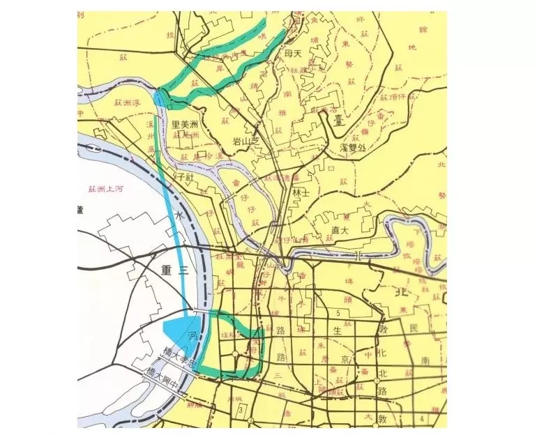
【How Were The Bricks Shipped From The Other Side of Taipei to This Place?】

The upper highlighted area is where the bricks were from, the bottom is where the Railway Department was.
Waterways played a vital role in logistics at the time, serving as major arteries for the movement of goods. While modern Taipei no longer features these waterways near the center of Taipei, early maps show a city crisscrossed by irrigation canals.

The Outline of Taipei, Dadaocheng, and Bangka (1895). The highlighted areas are the bureau and the canals.
These canals provided not only water resources for the citizens but also crucial transport routes. For example, Li Chun-sheng, known as the “Father of Taiwanese Woolong Tea,” strategically built his residence near the canal to facilitate the shipping of tea via water.

“The Residence of Li Chun-sheng” / Source: 臺北市立美術館
However, during the early Japanese colonial period, diseases like malaria posed significant challenges. To combat this, the Japanese government decided to fill in the canals, transforming them into roads. This measure aimed to improve sanitation and public health. Over time, these waterways were covered and disappeared from maps.
Recently, in efforts to reconnect Taipei citizens with water culture and decrease the temperature in the urban area, some canals, such as the Liugong Canal in the National Taiwan University campus, have been reveiled.
If you are interested know more about the stories of the rivers and canals in Taipei, please read the article.
---------------
【Why was the Machinery Bureau originally established near Beimen (North Gate)?】
The reason why the Machinery Bureau was built near Beimen was not an accident. According to Professor Hong Chih-Wen, this area, known as He’goutou, literally the Root of a River, during the Qing Dynasty, was selected for its strategic proximity to the Tamsui River. The river provided a vital water transportation link for delivering heavy machinery and equipment.
“This area marked the starting point of Taiwan’s modernization,” Professor Hong explained.
During the Qing and early Japanese colonial periods, this region served as Taiwan’s first factory center due to the same reason. The district gradually became the birthplace of Taiwan’s earliest “Science Park”, manufaturing modern products and materials like glasses and soaps.

The highlighted rectangles represent the factories of glasses and soaps.
Under Japanese administration, the Machinery Bureau was repurposed and gradually transformed into the Railway Department. Due to space constraints, the department was relocated to Songshan in 1935, and the area became a dormitory zone.
After World War II, the facility continued operation until 1990, when the current Taipei Main Station was finally built. The area was subsequently abandoned and officially handed over to the National Taiwan Museum in 2009, reemerging as the Railway Department Park, as what we see nowadays.
---------------
【Special Feature: Opening the Air-Raid Shelter during the 2024 Open House Taipei Event】

The Railway Department Park, designated as a cultural heritage site, comprises six historic buildings, including the iconic curved red-and-white hall which was mentioned above, a wooden staff dining hall, a reinforced concrete octagonal men’s restroom, and an air-raid shelter.
For most of the time, the shelter is closed to the public. However, in order to cooperate with the Open House Taipei Event, it was opened for the first time.
This shelter was designed by Enichi Torinono, a railway staff for the Japanese government. It served as a shelter for high-ranking railway staffs during World War II to avoid being attacked by the U.S. airforce.

The shelter has two levels: an upper cone-shaped section and a lower underground section. After the WWII, during the Chinese Civil War, the shelter’s interior was modified by KMT. The first floor was equipped with tactical planning boards, and the basement featured a detailed map of Taiwan’s railway system, including many now-defunct stations.


To protect military commanders, additional walls were built around the cone-shaped layer, with slanted air vents designed to prevent direct line-of-sight attacks.

If you are looking forward to knowing more about the "covered" areas of Taipei, please follow their social media accounts to get the up-to-date information!
---------------
The Railway Department Park encapsulates the rich history of Taiwan’s transition from Qing-era WATERWAY transport to modern RAILWAY networks, bearing witness to the nation’s industrial and infrastructural evolution.
Each structure within the park serves as a time capsule, preserving the stories of bygone eras. As historical research continues, this site will unveil further connections between the past and future, inspiring more people to admire and protect the cultural heritage.
---------------
Reference:
- 臺北市百年歷史地圖(Taipei Old Maps)
- 微笑台灣(Taiwan Cultural and Heritage Travel Megazine)
- 清代台鐵遺跡 (News about the remains of Machinery Bureau)
- 台南歷史名人:住吉秀松 (Introduction of Hidematsu Sumiyoshi)

回應文章建議規則: